Menu
1
Popular
Trending
Fresh
All
Substances
Funsubsters
GIFs
Videos
Media
Shop
Top
Top:
Posts
Comments
Users
Chat
More
Search
Submit
Sign Up
Login
Feedback Form
Fun Blog
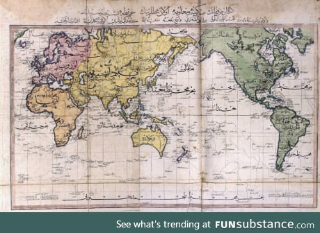
A map of the world as seen by the Ottoman Empire in 1803
Comments
Follow Comments
Sorted by time
timebender25
· 8 years ago
·
FIRST
They weren't to terribly wrong.
Some things are the wrong size, but what could one expect from an ancient map?
30
the_gayming_singer
· 8 years ago
...it's not ancient... 200 years ago most all of the land was discovered with the excpetion of small islands. The wrong sizes comes from the lack of satalie imagery, but this was the standarded for maps in the 19th centurary
5
·
Edited 8 years ago
timebender25
· 8 years ago
Ancient enough for me.
9
Reply
creativedragonbaby
· 8 years ago
South Pole not there?
Reply
guest
· 8 years ago
This was widely accepted and well-known in the 19th century I thought.
Reply
guest
· 8 years ago
I think op is trying to point out that they put Africa first.
▼
guest
· 8 years ago
They're near the center of the map.
5
Reply
Comments
Some things are the wrong size, but what could one expect from an ancient map?